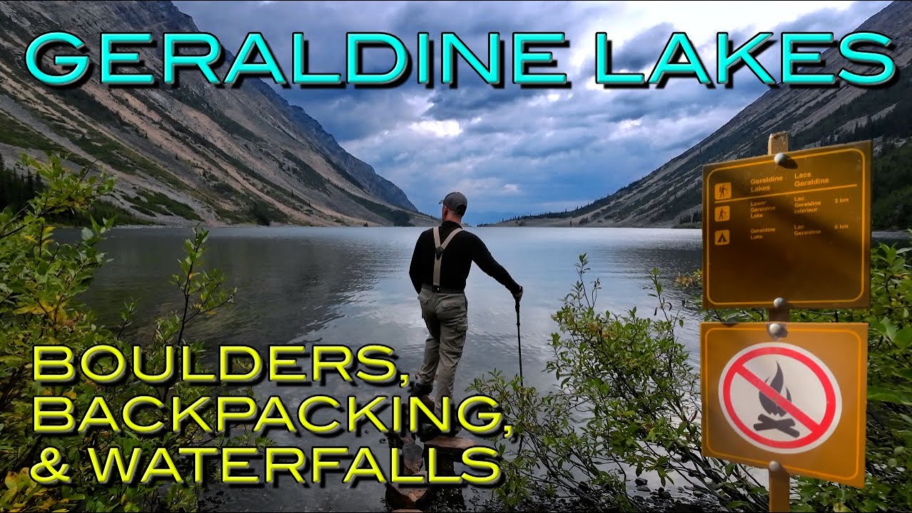
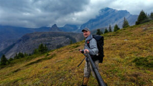
I recently completed a three-day backpacking trip through the entirety of the Geraldine Lakes Valley, a stunning alpine destination tucked into Jasper National Park. This journey takes you through diverse terrain—from gentle forested trails to steep boulder fields and cascading waterfalls—culminating in spectacular views of the upper valley and the towering peaks that define this region. The trailhead is located at the end of Geraldine Lakes Road, a seasonal access route that requires careful planning and the right vehicle to reach.
The Geraldine Lakes Valley represents one of those truly rewarding backcountry experiences where the effort you invest pays off in remarkable scenery and solitude. Located in Jasper National Park, this area showcases the rugged beauty of the Canadian Rockies, offering backpackers the chance to camp beside pristine alpine lakes and venture into rarely-traveled upper valleys where route-finding skills unlock even more dramatic landscapes. For those willing to tackle the challenging terrain and unpredictable weather, this trail delivers an unforgettable adventure.
In my video below, I walk through the experience exactly as shown and explained:
Getting to the Trailhead
Before you even begin hiking, you need to understand the logistics of reaching the Geraldine Lakes trailhead. Geraldine Road is a seasonal access road that opens from mid-June to late September, meaning this is strictly a summer and early fall destination. The road itself is rough gravel and demands high-clearance vehicles. This isn’t a route for standard sedans or low-riding cars—you’ll want something that can handle uneven surfaces and potentially washboard sections.
Trailers and RVs are not permitted on Geraldine Road, so if you’re planning a longer trip in the area, you’ll need to establish a base camp elsewhere or arrange alternative accommodations. I always recommend checking 511.alberta.ca before heading out to confirm whether the road is actually open. Seasonal conditions, maintenance, or wildlife activity can sometimes affect access, and the last thing you want is to drive all the way there only to find the gate closed.
The Hike to First Geraldine Lake
The journey begins with a gentle, forested hike to First Geraldine Lake covering about 1.8 kilometers. This opening section is relatively easy and allows you to warm up before the real challenges begin. The forest provides welcome shade and the trail is well-defined, making for pleasant walking as you ease into the rhythm of your pack and the wilderness around you.
First Geraldine Lake itself is beautiful, but it’s really just the beginning. After reaching the lake, the trail climbs steeply at the end of the water body, and this is where the character of the hike changes dramatically. The gradient increases and you start to gain elevation more rapidly, signaling that the easy walking is behind you.
Crossing the Boulder Fields
Beyond First Geraldine Lake, the trail travels across a large boulder field marked with a series of cairns. This is one of the more distinctive and challenging sections of the route. Boulder fields require careful foot placement and balance, especially when you’re carrying a heavy backpacking pack. The rocks are uneven, and gaps between boulders can catch your boot if you’re not paying attention.
The cairns are essential here because the official trail isn’t always obvious when you’re navigating through jumbled rock. I found myself scanning ahead frequently to spot the next cairn and ensure I stayed on route. These boulder fields can be particularly tricky in wet conditions—something I experienced firsthand later in the trip. When the rocks are wet, they become very slippery, adding an extra layer of difficulty and requiring even more caution with each step.
Navigating through boulder fields with a large pack can be genuinely difficult. The weight on your back affects your balance, and maneuvering between larger rocks sometimes means taking your pack off temporarily or carefully choosing your line through the jumble. It’s slow going at times, but it’s important not to rush and risk injury in such remote terrain.
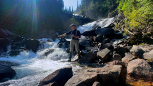
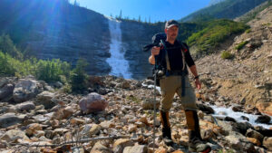
The Waterfall and Headwall
At the 4.2-kilometer mark, you encounter an impressive waterfall and a steep headwall. This is one of the visual highlights of the lower section of the trail and a good spot to take a break, refuel, and appreciate how far you’ve come. The waterfall is powerful and scenic, cascading down the rock face that you’ll soon be climbing.
The headwall itself is steep and demands effort. From the top of the headwall, the trail continues to a rocky ridge, and you’re rewarded with increasingly expansive views of the valley and the surrounding peaks. This elevation gain is significant, and by the time you reach the top, you’ve definitely earned the scenery that awaits.
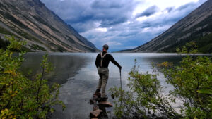
Second Geraldine Lake and the Campground
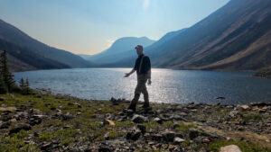
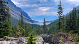
The trail continues across several more boulder fields along Second Geraldine Lake. The lake is stunning—larger and more dramatic than the first, with steep walls rising on either side and the water reflecting the surrounding mountains. The campground is located at the far end of the second lake, across a small creek.
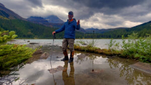
This is where we spent the night, at the head of the beautiful Second Geraldine Lake. One of the best features of this campground is that basically all the campsites have an amazing lakeview. Waking up to that scene—calm water, towering peaks, and the quiet of the backcountry—is an experience that makes all the boulder-hopping and steep climbing worthwhile.
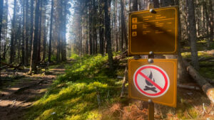
It’s worth noting that there is a two-night maximum stay at this campground, so you’ll need to plan your itinerary accordingly. Also, during early season when snowmelt is at its peak, the campground can flood. If you’re planning a trip in mid-June or early July, be aware of this potential issue and prepare for wet conditions around your tent site.
Exploring the Upper Valley
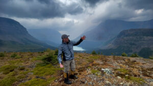
With experience of the area, we decided to continue exploring the upper valley and its lakes beyond the campground. This is where the adventure really opened up for us. There are no official, signed trails beyond the campground, so route-finding skills are required. This isn’t a section for beginners or those uncomfortable navigating without a clear path.
But the rewards are well worth it. Once we hit the treeline and saw the amazing Mount Fryatt with all its ridges and glaciers, we were captivated. Mount Fryatt is a massive, imposing peak, and seeing it up close from the upper valley provides a perspective you simply can’t get from the lower trails. The scale of the mountain, the intricate patterns of its glaciers, and the stark beauty of the alpine environment are absolutely breathtaking.
We were so taken by the scenery that we kept hiking for several hours in the rain just to record these amazing views for our viewers. The weather in the alpine can change rapidly, and we found ourselves in wet conditions as we pushed deeper into the upper valley. Rain in the mountains always adds a layer of challenge—visibility decreases, rocks become slippery, and staying warm and dry becomes more difficult. But we were determined to capture the majesty of this landscape, and despite the conditions, we pressed on.
The upper lakes beyond the campground are wild and remote. Without maintained trails, you’re picking your way across talus slopes, around tarns, and over open alpine meadows. Navigation requires attention to the terrain, a good sense of direction, and ideally a map and compass or GPS device. But for those with the skills and confidence, this area offers solitude and scenery that few people experience.
Important Considerations for This Trail
There are a few important notes about this hike that I think are critical for anyone considering the Geraldine Lakes Valley. First, this trail can be challenging for children and dogs. The boulder fields, steep sections, and overall distance make it a strenuous undertaking. If you’re planning to bring kids or pets, carefully assess their fitness level and experience with this type of terrain.
As I mentioned earlier, boulders become very slippery in wet conditions. This isn’t just an inconvenience—it’s a real safety concern. A slip on wet rock with a heavy pack can lead to serious injury, and you’re a long way from help. Take your time, use trekking poles for stability, and don’t hesitate to wait out heavy rain if conditions become too hazardous.
Navigating through boulder fields can be difficult with a large pack. I experienced this firsthand and found that sometimes the best approach is to move slowly and deliberately, testing each foothold before committing your weight. It’s not a race, and patience is your friend in these sections.
The two-night maximum stay at the campground means you need to be efficient with your time if you want to fully explore the upper valley. We used our time wisely, setting up camp and then venturing beyond on day hikes to see as much as possible.
Finally, be aware that the campground can flood with snowmelt during early season. Check conditions before you go, and be prepared with a tent site strategy that accounts for potential water accumulation.
My Journey in the Canadian Rockies
I’ve been exploring the Canadian Rockies since 2020 through my Eric Tremblay Adventures YouTube channel, documenting everything from iconic landmarks to hidden backcountry gems. If you’re looking for things to do in Jasper National Park, there’s so much to discover—Maligne Lake, Spirit Island, and Athabasca Falls are just the beginning. For those searching for hikes in Jasper National Park, options range from the accessible Valley of the Five Lakes to the challenging Skyline Trail, with countless opportunities along the Icefields Parkway.
Planning where to stay in Jasper National Park involves choosing between campgrounds, cabins, or hotels depending on your preferences and budget. Similarly, if you’re looking for things to do in Banff National Park, destinations like Johnston Canyon, Lake Louise, and Moraine Lake draw visitors from around the world. Searching for hikes in Banff National Park reveals trails like Tunnel Mountain, Sentinel Pass, and Bow Glacier Falls, each offering unique perspectives on this remarkable landscape.
For accommodations, knowing where to stay in Banff National Park—whether in campgrounds, cabins, or hotels—can make or break your trip. Beyond Jasper and Banff, I’ve also explored Yoho National Park, where you can visit Natural Bridge, Takakkaw Falls, and Emerald Lake. The hiking in Yoho National Park is world-class, with routes like the Lake O’Hara Alpine Circuit, Iceline Trail, and Hamilton Lake Trail offering incredible alpine experiences.
My content covers road trips, travel guides, campground reviews, and itinerary information that I hope proves invaluable to your trip planning in Alberta or British Columbia. Whether you need a detailed trail breakdown or suggestions for where to stay in Yoho National Park—from campgrounds to cabins to hotels—I aim to provide practical, experience-based information.
Resources for Your Trip
If you’re planning your own backcountry adventure and struggling to secure campsites, I recommend checking out Campnab for scanning camping cancellations. You can find that resource at campnab.com/r/s5nrrv. Backcountry sites can book up quickly, especially in popular parks like Jasper, and having a tool to alert you when cancellations appear can make the difference between getting your preferred dates or missing out entirely.
For those curious about the gear I use on trips like this, I maintain a detailed list at EricTremblayAdventures.com/Gear. From packs to tents to clothing layers, I share what has worked well for me in the demanding conditions of the Canadian Rockies.
I also provide a video map at EricTremblayAdventures.com/map that can help you visualize the route and understand the geography of the areas I explore. Maps are essential for trip planning, and having a visual reference alongside the video can enhance your understanding of the terrain.
Final Thoughts on the Geraldine Lakes Valley
The Geraldine Lakes Valley is a strenuous but rewarding backpacking trip that showcases some of the best alpine scenery Jasper National Park has to offer. From the forested approach to the dramatic boulder fields, the impressive waterfall and headwall, and finally the stunning campsites at Second Geraldine Lake, every section of this journey offers something special.
For those willing to venture beyond the campground into the upper valley, the experience becomes even more extraordinary. The sight of Mount Fryatt with its ridges and glaciers, the wild character of the unmarked terrain, and the solitude of truly remote wilderness make this an adventure that stays with you long after you return home.
The challenges are real—slippery boulders, steep climbs, unpredictable weather, and the need for solid route-finding skills in the upper reaches. But for experienced backpackers looking for a true wilderness experience in the Canadian Rockies, the Geraldine Lakes Valley delivers in every way.